We care about king tides because they're harbingers – basically, indicators – of what's to come in the decades ahead. Scientists say today's kings will be more like common tides just a half-century from now as sea levels continue to rise. So think of this year's king tides as windows into that future.
That's a big part of why Catch the King was started in 2017 in Hampton Roads, to help citizens contribute to the science of understanding this threat along our coast.
Follow the links below to get a fuller picture of what's happening with the tides and our tidal waters and what you can expect as time goes on.

They're tides that are driven much higher than normal by astronomical conditions, basically how the earth, moon and sun are aligned and how close the moon and the sun are to our planet. In Virginia, that typically happens in the fall. Learn more about king tides.
It's a simple matter of looking at tide charts. You can search many years in advance for the astronomical tide predictions for hundreds of tide stations in the U.S. Click on any of the Virginia stations on this list and you can check out predictions for any 31-day period. For the station at Sewells Point in Norfolk, just as an example, there's a king tide predicted for Sept. 22, 2040.
Most certainly. Throughout coastal Virginia and along other U.S. coastlines, residents have been reporting more flooding over the years on pleasant days. We've taken to calling these “sunny day” floods or high tide floods. Oftentimes these come at the time of our king tides. The National Ocean Service even has an animation to illustrate such flooding.
Definitely. Wind and rain here and big waves stirred by storms far out to sea can cause higher-than-average tides, even flooding tides. That's why, if you live near water, you should keep an eye on the short-term tide forecasts that take into account all of the latest weather factors. The National Weather Service has a handy page to get a 72-hour outlook for tide stations all across the mid-Atlantic.
You bet. Virginia has some of the highest rates of relative sea level rise in the U.S. See the chart below. It shows that five of the 15 tide stations in the U.S. with the highest rates of sea level rise are in Virginia. Sewells Point, in the heart of Hampton Roads, has been averaging an increase of 4.62 millimeters a year.
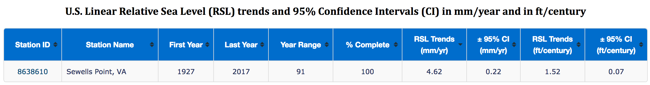
For Sewells Point, that adds up to more than a foot and a half of sea level rise over the past 90 years. So there's less margin for safety when it comes to high tides these days.
Scientists say we're being hit by a double whammy. Besides the ocean rising, we're also affected by subsidence the sinking of our land. There's some hope that a Hampton Roads Sanitation District project called SWIFT (Sustainable Water Initiative for Tomorrow), currently with a demonstration-scale research center in Suffolk, Virginia, may slow the rate of subsidence. It involves using highly treated wastewater, further treated to meet drinking water standards, to replenish the confined Potomac Aquifer. Even if SWIFT provides some relief from sea level rise, however, some researchers say another factor may become more significant: a slowing Gulf Stream.
Potentially, deadly serious. Scientists says there's increasing evidence sea level rise is accelerating globally. And that means more risks for cities like Virginia Beach, Norfolk and Newport News. Click here to search for how Climate Central gauges the risk to your city or county. Another effort to assess localities' vulnerability are annual Sea-Level Report Cards compiled by the Virginia Institute of Marine Science.
The Hampton Roads Planning District Commission, which represents cities and counties across the region, has gathered tools to help residents understand sea level rise. The Commonwealth Center for Recurrent Flooding Resiliency, a partnership of Old Dominion University, VIMS and the College of William & Mary's Virginia Coastal Policy Center, also offers resources to cities and counties dealing with the problem. Most Hampton Roads localities have programs or offices devoted to sea level rise and resilience A number of them are partners in StormSense, an innovative program at VIMS to monitor flooding from storm surge, rain and tides.
It's simple. Follow this link.